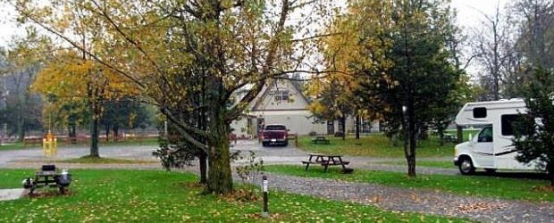
Cypress View Campground, Santee State Park, Santee, South Carolina
Eingestellt von Gisela am 12. Juni 2011 - 22:44

Typischer Statepark Campground, auf der Westseite gelegen, schön.
Nordamerika im Wohnmobil erleben!
Typischer Statepark Campground, auf der Westseite gelegen, schön.

Der Lake Eufaula State Park verfügt über zwei Campgrounds. Die Premium sites liegen direkt am Wasser und man hat keine direkten Nachbarn.

Wahnsinns-Campground für eine Nacht im Zelt 70 Meilen westlich vor Key West nach Bootsüberfahrt mit dem Katamaran zum Dry Tortugas National Park. Hier kann man u.a schnorcheln, baden und ein beeindruckendes Fort besichtigen.

Alternative zum Boondockingplatz nur 100 Meter landeinwärts, wenn das Meer zu rauh ist um direkt am Strand zu übernachten.
- noch kein Bild -
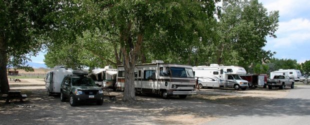
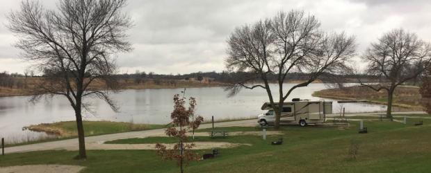
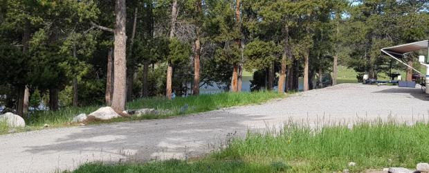
Der einfache Campground liegt am Nordufer des Rimrock Lake. Ein Loop mit 39 sites im Wald und keine site verfügt über Seeblick / Seezugang. 20$ pro Nacht, keine hookups, 6 vault toilet

Am Ufer des Kern Rivers liegender privater Campground, nur 1 Meile von Kernville entfernt

ACHTUNG: Nach Umbau zu einem Resort keine Möglichkeit mehr für Camping !
Ein Campground mit allen facilities in der Nähe von Kingston Ontario. Idealer Campground, wenn man eine Bootstour durch die 1000 Islands unternehmen will. Er ist allerdings recht teuer!

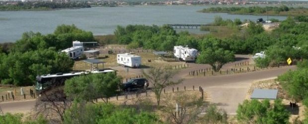
Campground mit 128 Sites ohne Strom und Wasser. Sehr schön am See gelegen, wobei die Sites in Ufernähe sehr uneben sind. Es gibt nach meiner Erinnerung weder Strom noch Wasser.

Ein schöner Campground am West-Ufer des Lake Michigan

Gebirgsregion im Nordosten des Bundesstaates New York mit wunderbaren Seen und Flüssen mit zahlreichen Wandermöglichkeiten. Hier befinden sich auch die Olympischen Stätten von Lake Placid.

Der CG ist gut geeignet als Zwischenstopp zum Mt. Rainier. Er liegt direkt am Alder Lake, einem Stausee.

55 Campsites mit E-Hookup. Tolle Wanderungen, große Abstände zu den Nachbar-Sites.

Ein Campground am See auf dem Weg von Chelan nach Winthrop in der Nähe von Pateros, ca 2 Meilen abseits des Hwy-97

Schön angelegt, aber eng. Man steht auf einer Art Terasse Seite an Seite mit den Nachbarn. Full Hook-up ist möglich. Der Platz liegt recht nah an der Interstate, dementsprechend hört man Straßenlärm.

Achtung: der Anaheim RV Park ist seit 1. September 2020 dauerhaft geschlossen.
Sehr gepflegter Campground in Anaheim, ideal für den Besuch in Disneyland. Laundry, Pool, free WiFi.

Ein wirklich toller CG für dern Besuch von St. Augustine. Die eingewachsenen sites garantieren absolute Privatsphäre, man merkt kaum, das man Nachbarn hat. Der Schatten hat teilweise aber den Nachteil, dass es an der site recht dunkel ist. Toller Strand, der allerdings so weit weg ist, so dass man fahren muss.

Der Anderson Cove Campground liegt direkt am Ufer des Pineview Reservoirs im Uinta-Wasatch-Cache National Forest, ca. 10 mls. östlich von Ogden und der I-15.

Ruhiger, abseits vom Highway gelegener (Mile 265 / KM 427 Alaska Highway) Regional Park, wird hauptsächlich von Einheimischen aus Fort Nelson (28 km nach Norden) genutzt.
Keine hookups, Feuerholz kostenlos, Baden und Fischen möglich

Ein wunderschöner einsam gelegener Campingplatz auf einer Insel im Großen Salzsee bei Salt Lake City. Es ist ein Erlebnis im See zu baden, Duschen sind am Strand vorhanden.

Campground mit allen Ausstattungen eines privaten Platzes incl. Pool. Direkt am Colorado gelegen. Viele Bäume, vor allem direkt am Ufer.

Schöner Campground im Los Padres National Forest, er bietet rustikale als auch moderne Campsites
Ash Springs ist eine heiße Quelle (about 80 to 92 degrees), ganzjährig.

65 Full Hookup, 13 Electric & Water, davon 45 im Schatten, er hat einen Minimarket mit RV Zubehör. Die Sites sind relativ eng und meist aus Schotter. Toiletten, Duschräume und Pool sind sehr sauber.

Einer der Top-Plätze an der Ostküste: Assateague Island National Seashore bietet gleich mehrere Übernachtungmöglichkeiten, sowohl an der Atlantikseite als auch an der Bucht gelegen.

Dieser wunderschöne Statepark stellt eine gute Alternative dar, wenn man es nicht geschafft hat, zu Beginn des Buchungsfensters (6 Monate im Voraus) im benachbarten National Park einen Campground zu reservieren.
-- noch kein Bild --
Privater Campground auf Cape Cod

Wunderschöne Badestelle im Fremont River, östlich vom Capitol Reef NP, die leider geschlossen wurde.

Der State Park bietet ein wirklich schönen Strand zum relaxen und schwimmen. Man hat vom Strand einen herrlichen Blick auf die Seven Mile Bridge und bei zu starker Sonneneinstrahlung bieten die Picknick-Shelter am Strand ein wenig Schatten. Klasse Campground.

Zu diesem Campground im Balmorhea Statepark gehört ein natürliches Schwimmbad, welches mit Quellwasser gespeist wird und eine Temperatur von ca. 23°C während des ganzen Jahres hat.

1 Millionen Gallonen pro Stunde fließen im Balmorhea SP in ein 2 Hektar großes Schwimmbecken und in Kanäle ringsrum. Das Wasser hat eine ganzjährig gleichbleibende Temperatur von 23°C.
Auf dem Weg zwischen Los Angeles und dem Joshua Tree. Pool, Duschen und Laundry sehr sauber. Kleiner Shop an der Rezeption, man kann Propan auffüllen lassen.

Privater Campground an einem See im Chilcotin District mit der Möglichkeit zur Vogelbeobachtung, insbesondere des American White Pelican -- aber auch für mehrere andere Aktivitäten

Die Barrier Islands, auch genannt die Golden Isles of Georgia, sind Georgias ca. 100 Meilen langer Atlantik-Küste vorgelagerte Inseln mit natürlichen Stränden, weiten Sumpfgebieten, maritimen Wäldern, historischen Stätten und reichlich Wildtieren.
Da die Inseln besonders im Frühling gerne besucht werden, sollte man sich besonders über die Tage des "Spring Break" informieren und sie an diesen Tagen meiden (oder sich darauf einlassen)

Der Campground des Bear Creek Provincial Park liegt direkt am Okanagan Lake. Meisten Sites sind durch Bäume oder Sträucher voneinander getrennt.

Der RV Park wird üblicherweise von Anglern benutzt. Kleines Restaurant vorhanden. Angelbedarf und Bootsverleih. Alles etwas einfach, aber sehr familiär.

Üblicher KOA-Standart: Pool, Laundry etc. Ruhige Lage. Grosser Kiesplatz unter Bäumen.
Hinter dem KOA Blick auf Felder und in der Ferne Berge.

Gut erschlossenes Naherholungsgebiet in ruhiger Lage abseits der I-44 und der Stadt Chandler gelegen. Stellplätze der Area C mit Anschlüssen, Dump Station nicht vorhanden. Restrooms mit Duschen. Bademöglichkeit mit Sandstrand.
Guter Übernachtungsplatz zum Besuch von Fredricksburg, Luckenbach und Stonewall.

Toller State Park mit See (Fortune Lake), 3 Campground-Loops, der älteste (A) im Wald, die anderen z.T. etwas lichter. Recht viel Platz und Privacy auf den Sites. Der See mit Badestrand ist nicht direkt am CG dran, aber zu Fuß erreichbar (von unserer Site A14 der kürzeste Weg, 5-10 min). Schöner Sandstrand am See, gepflegt durch Personal

Sehr schön gelegener und ruhiger RV Park am Big Bear Lake. Nicht günstig, aber sehr große und schöne Plätze, die Anlage ist super gepflegt.

Die Sites sind sehr groß dimensioniert, verfügen über einen Shelter mit Tisch und Bank, Feuerstelle, Grill und Full Hook Up.

Schöner Statepark nahe der Golfküste. Sites unterschiedlich groß, teilweise recht nah beieinander. Es gibt diverse Angebote zur Freizeitgestaltung und (kurze) Wandermöglichkeiten.

Sehr gepflegter, direkt am Colorado River gelegener Campground. Die Sites am River liegen unter Bäumen und bieten ein schönes Panorama. Die übrigen Sites sind eher Stellplätze mit Kies und Schotter.

Der an einem naturbelassenen See gelegene Campground liegt in der Nähe des Westernstädtchens Winthrop (3 Meilen südlich) im wunderschönen Methow Valley. Geöffnet Mitte April bis Ende Oktober.

Großer State Park Campground mit 147 Standard sites und 20 Hook-up-Sites, 18 Duschen. Großzügig angelegt im Wald, jedoch größtenteils nicht allzu dunkel.

Der Biscayne National Park liegt in Süd-Florida und erstreckt sich über die Biscayne Bay und die nördlichsten Inseln der Florida Keys. Er besteht zu 95 % aus Wasser !

Sehr schöner CG an einem Stausee (Alcova Reservoir) auf der Verbindung zwischen Lander und Casper gelegen. Anfahrt etwas rauh.
Privater CG mit allen dazugehörigen Annehmlichkeiten: Full-Hookup, Internet, Pool, Spielplatz, Minigolf, Laundry.
In der Nähe von Helena gelegen, über die I-15, den Hwy-453 und eine kurze Gravel Road zu erreichen. Mit dump station, water, e-hook-ups, vault und flush toilets, fire pits.

Grosser privater Campground mit Seezugang, Bootsverleih (Boote, Kajaks etc.).
Der Platz ist ganz schön angelegt, aber vorwiegend mit sehr grossen RV's belegt. Die Sanitäranlagen sind sauber, aber für die Grösse vom Campground sind nur wenige vorhanden. Wifi, falls das interessant ist, ist nicht besonders gut.

Kristallklares Wasser zum Baden und Schnorcheln im 23 ° warmen Wasser der Quelle --- solange keine Manatees da sind (Manatees season Mitte November bis März. Der Campground bietet sehr schattige Plätze, die fast völlige Privatsphäre garantieren!
-- noch kein Bild vorhanden --
Es ist ein normaler KOA Stadtcampground ....ergo die meisten Sites sind eng und es stehen sehr große Womos auf den Sites. Der Campground ist sehr sauber und hat einen schönen Pool (überdacht) mit Spa !

Ein auch von vielen Dauer-Campern belegter privater Campground im Frank G. Bonnelli Regional Park am und über dem Puddingstone Reservoir in der Nähe der I-10 auf dem Weg zum Joshua Tree National Park

The recently completed 8 mile long Million Dollar public beach is a great place to find shells or just enjoy the sun and surf.

Panaca Hot Spring oder auch Panaca Swimming Hole ist ein (Stau-) See mit ca. 35°C Wassertemperatur.

Klasse Campground in New Mexico. Auf dem Weg von z.B. Albuquerque nach Calsbad Caverns oder von Amarillo nach White Sands.

Ein toller einfacher Platz am See. Günstig, aber ohne Strom. Im Sommer kann es sehr heiß dort sein.

Strategisch günstig an der Hwy 155, daher auch ein bisschen laut an den oberen Sites. Seeufer des Lake Isabella zu Fuß erreichbar.

Wir waren am 24.05.2015 auf diesem Platz und auf der Site 14 für 26 CAD. Diese Site ist wohl gleichzeitig eine der schönsten des ganzen (und mit 39 Sites eher kleinen) CG. Der Platz ist "unserviced", es gibt also kein Hook-Up und nur das Nötigste, das aber in wieder mal sehr schön angelegter Form.

Am Highway 1 gelegener Campground in Key West ( Stock Island). Sehr gut ausgestattet, schöne Plätze am Wasser, Innenstadt von Key West mit dem Bus in etwa 20 Minuten erreichbar.

Der vordere Teil des CG liegt an einem schönen Badesee. Die große Liegewiese am See und der See an sich sind traumhaft.

Kleiner Campground mit 18 Non-Electric Sites am Nordende und Ostufer des Boysen Reservoir, gut erreichbar über den Hwy-20

Gepflegte Anlage mit wenig Not zum Levelling und sauberen Toiletten, jedoch wirklich sehr nah an der Hauptstraße.

Dieser private Campground an der Chesapeake Beach füllt sich schnell besonders an Sommerwochenenden.

Kleiner State Park 50 km östlich vom 100 Miles House.
-- noch kein Bild vorhanden --

Kleiner CG direkt am Similkameen River mit 17 Stellplätzen. Keine Duschen, kein Wasser, keine Dumpinggelegenheit. Dafür ein toller Strand mit Badestelle im Day Use Bereich.

Südlich von Tobermory ersteckt sich quer über die Halbinsel der Bruce Peninsula National Park. Die Ufer der Georgian Bay sind mit überhängenden Felsen, Höhlen, stillen Buchten und glasklarem Wasser wunderschön aber nur zu Fuss erreichbar. Wegen der enormen Wassertransparenz ist die Küste des Parks ein Tauchparadies.

Campground an der UT-SR 12 zwischen Kodachrome Basin SP und Bryce Canyon NP. Möglicher Ausweichplatz, falls in den beiden Parks keine Sites mehr frei sind.

Der Park hat 206 Premium Campingplätze mit allen Annehmlichkeiten einschließlich Sewer. Zusätzlich zu den Premium-Campsites gibt es 70 sites auf einer Wiese mit Blick auf den Golf von Mexiko.

Schöner sauberer Campground mit großzügigen Sites direkt am See.

Take Interstate Rt 95 South to Rt 4 South to Rt 1 South, to the town of Charlestown, turn at Burlingame Campground Sign.

Wunderbare Lage zwischen Redwoods, am Eel-River, Wanderungen. Schönes Visitor Center.

Ein Großteil der Stellplätze haben Rasenfläche und sind sehr gut gelevelt; die sanitären Einrichtungen waren sehr sauber sowie der CG insgesamt sehr gepflegt.

Wenn es am Pazifik voll ist, hat man hier eine gute Ausweichmöglichkeit. Baden, Laundry, kleines Museum.
--- Leider noch kein Bild vorhanden ---
Mitten im Herzen von Nebraska nur 6mi nördlich von Burwell gelegener kleiner Stausee mit insgesamt 3 Campgrounds verteilt auf beiden Seiten. 122 durch Bäume voneinanderr abgegrenzte Stellplätze mit Elektrik im südlichen Teil des Sees (Nunda Shoal und Homestead Knolls) sowie 55 weitere im Nordteil (Hannaman Bayou).
Sehr sauber auf dem Platz und in den Duschen, Pool; sehr enge Sites ohne Sitzgelegenheit; Laundry -- ein guter Übernachtungsplatz.

Sehr großer, lebhafter und teurer Campground auf den Outer Banks direkt am sehr schönen Strand.

Die einzelnen Stellplätze des Campgrounds haben viel Grün rundherum, gute sanitäre Anlagen.

Privater Campground bei Wheatley, in der Nähe von Point Pelee (ca. 20min Fahrzeit). Platz für viele Dauercamper und 86 Overnight Stellplätze, schöne Anlage am Erie-See mit Strand bzw. im Wald dahinter.

Schöner mitten in South Lake Tahoe gelegender Campground im Wald. Vom Lake Tahoe ist er nur durch die Uferstraße getrennt. Sites wahlweise mit und ohne hook-up.

Die Aussicht von den Felsen über das Marschland und Gloucester inst wirklich atemberaubend.

Moderner KOA mit guten Sanitärräumen. Direkter Zugang zum wunderschönen Sandstrand. Alles sehr gepflegt. Kein Schatten. Cabins vorhanden.
Ein feiner RV-Park an der Oregon-Pazifikküste, direkt am Cape Kiwanda - nicht ganz billig, aber es wird für den Preis was geboten.

Schöner State Park im Panhandle von Texas, der verschiedene Camping-Möglichkeiten bietet: von Primitiv Camping im Canyon selbst bis Wasser/Electric Hook-up am Canyon Rand. Bademöglichkeiten im See

Im Wald direkt an der 101 landeinwärts gelegener Campground in sehr einsamer Lage. Von der Day Use Area noch 5 Minuten zum wunderschönen menschenleeren Strand.

An der wunderschönen Bucht des Caspar Beach. Campground aber sehr eng, meist voll.
- noch kein Foto vorhanden-
Nicht schön, gerade noch okay für Übernachtung. Direkt an der Autobahn und auch noch eine Eisenbahn, deshalb sehr laut. Super-Eng, leidlich sauber.

CG hat E-und W- Hook Up's, liegt am Colorado mit schönem Strandbereich und auch nahe der Straße. Der Park ist eine gute Alternative zum Buckskin Mountain State Park

Weit entfernt von Highways & Highlights liegt dieser kleine Campground des BLM - und ist trotzdem selbst fast ein Highlight. 100m stromauf ist der Day-Use-Bereich mit Badepool.

Normaler KOA-Standard, Pool, Laundry, kleiner Shop, sauber. Direkt an der Main Street, darum recht laut. Enge Sites. Für eine Nacht (und waschen) okay.

Keine Schönheit, aber ideal gelegen um am nächsten Morgen die Fähre auf die Outer Banks zu nehmen.

Großer Platz oberhalb des Ufers auf sandigem Gelände am Lake McConaughy. Plätze mit und ohne Strom, teilweise mit Blick auf den See.Wasser an zentralen Zapfstellen, Dump Station.

Campground mit direktem Zugang zum Lake Ontario hat. Die Plätze sind grosszügig in einer schönen Grünanlage verteilt.
--- kein Bild vorhanden ---
Nur 6 mls von der ElMonte-Station in Bellingham entfernt. Sauber, Pool.

Sehr schöner Camground mit Badestrand. Besonderheit: Die Wasserzapfstellen sind zusammengefasst -ein Hahn mit drei-vier Abgängen. Teilweise langer Wasserschlauch nötig, Sites nach diesem Kriterium aussuchen.

Schön in einem Waldgelände gelegener Campingplatz, günstig für die erste Nacht nach der Übernahme eines Wohnmobils in Middlebury oder Elkhart.Plätze mit und ohne Strom, Dump Station.

Gute erste/letzte Station bei Übernahme/Abgabe in Denver. Baden im See.

Majestätische Klippen und ein weitläufiger Blick auf die Hochebenen begrüßen die Besucher in einem der neuesten State Parks von Colorado, dem North Sterling State Park.

Kleiner Campground der sich ca. 1,3 mi entlang des Südostufer des Bear Lake erstreckt. Er umfasst 56 einfachste Sites ohne Anschlüsse. Keine Duschen, nur einfache Toiletten. keine Dumpmöglichkeit.

Einfacher, ruhiger NF-Campground direkt am See
--- kein Bild vorhanden ---
Clear Springs Campground is located along the shore of 30,000-acre Wright Patman Lake within the piney woods of northeast Texas. This place has great views and has a lot of wildlife to see. The Clear Springs Campground offers 41 with 30 amp electric hookups and sewer, 22 with 50 amp electric hookups, 25 with 30 amp electric hookups, 3 screened shelters for camping, 10 non-electric sites, a group camping area, and a day-use group picnic shelter.

Südl. von Fort Worth gelegen großzügig angelegter Campground mit fünf Camping Areas. Hier die Cedar Grove Aera mit Stromanschluß. Die verschiedenen Camping Areas sind rings um den See angelegt.

Insgesamt gibt 4 loops, zwei davon mit Elektroanschlüssen. Liegt an einem See, mit Bademöglichkeit und Bootsrampe.
Sehr gut, wenn man für den Cody-Besuch einen Pool und Spielplatz haben möchte. Dafür etwas weiter außerhalb, aber es gibt einen Shuttle.
--- Leider noch kein Bild vorhanden ---
Der einzige See in Kansas, auf dem offiziell Wassersport erlaubt ist, gehört der City of Coldwater. Die auf beiden Seiten des Reservoirs direkt am Ufer gelegenen beiden Campgrounds haben insgesamt 100 Stellplätze in allen Kathegorien. Toiletten, Duschen und eine Dumpstation sind vorhanden.

Direkt am American River gelegen, fußläufig in den Marshall Gold Discovery State Park.

Der etwas enge CG liegt im gleichnamigen, sehr schön gelegenen Statepark. Er besitzt eine Dumpstation und im Sanitärgebäude sind warme Duschen.

Ein idyllischer National Forest Campground, nur wenige Fahrminuten vom Hwy-395 entfernt, zwischen Mammoth Lakes und Bishop gelegen.
-- noch kein Bild --
Gelegen in der westlichen Region von Maine zwischen Seen und Bergen bietet dieser private Campground neben dem Naturerlebnis 50 Campsites mit Strom, warmen Duschen und auch Cabins. Der Swift River fließt direkt am Platz vorbei.
Mit Blick auf die Mesa Verde gelegen -- typischer KOA-Platz, sauber, gepflegt. Bis zum Farview Visitor Center im Park sind es noch ca 25 Meilen auf kurvenreicher, ansteigender Strecke.

Kleiner, unserviced CG in traumhafter Lage mit direktem Strandzugang im Kouchibouguac NP. Gute 20km von allen weiteren Einrichtungen des Parks entfernt.

Privater Campground mit Full-Hookup, beheiztes Schwimmbad, Minigolf, Spielplatz Tennis, Snack Bar. Guter Ausgangspunkt für die Besichtigung der umliegenden Orte wie Kitchener, New Hamburg, Heidelberg, St. Jacobs u.a.

Netter Platz für einen Zwischenstopp in der San Francisco Bay Area. Sauber, aber teuer.

Relativ groß, sites ganz nah an der Georgian Bay, eines Teiles des Huron-Sees. Felsiger Strand.

Der Deception Pass State Park liegt an der Meerenge im Nordwesten des Bundesstaates Washington, die Whidbey Island von Fidalgo Island trennt. Er liegt neun Meilen nördlich von Oak Harbor und neun Meilen südlich von Anacortes.

Großer, gut ausgerüsteter Campground am Ufer des Lake Havsu ganz in der Nähe der London Bridge
Die Sites direkt am Ufer haben W/E-Anschluss. Die Sites "oben" haben Full-Hook-Up.

Wunderbarer Platz in der Nähe (ca. 35 Mi) von Manhattan. Ruhig gelegen mit Full Hook up Sites. Baden/Angeln/ Golf alles ist hier möglich.

Gepflegter Campground, mit vielen Stellplätzen direkt am Lake Greeson. Area A+B mit relativ engen und schiefen Sites, Area E ist neu und gelevelt.
Gepflegter KOA Campground mit guter Sanitärausstattung an der S Cooper Street in Arlington.

Direkt an der I-65 mit kleinem See und RV Werkstatt, kein KOA Campground mehr

Der Park ist privat und gated! Alles natürlich sehr sauber und ordentlich. Sehr höfliches, hilfsbereites Personal. Zum Strand zu Fuß nur wenige 100 Meter und sehr ruhig. Bushaltestelle vor der Tür welcher nach Coronado fährt .

In einem lichten Wald in der Nähe der Dünen gelegen. Wunderbare kurze Wanderungen durch die "Bird Sanctuary", am Strand entlang oder auch zum nahe gelegenen Fort Gaines.

Typischer KOA Campground mit 350 Sites. Sanitäranlagen sauber, Pool und kostenloses WiFi.

Herrlicher Platz am Deadman’s Basin --- einen Kilometer Gravel von der US-12 entfernt auf der Hochebene in 1200 m Höhe gelegen.

Sehr gepflegter wäldlich gelegener KOA Campground. Perfekt Stopp nach WoMo-Übernahme und Ersteinkauf. Ideal für Familien mit Kindern,ausgestattet mit Pool, Spielplatz sowie Hüpfburg. Free Wifi hat super funktioniert. Saubere sanitäre Anlagen.

Privater Platz mit eher engen Stellplätzen, sehr gute sanitäre Anlagen, direkter Strandzugang

Einer von 4 Campgrounds im Cultus Lake Provincial Park, unmittelbar neben Clear Creek Campground gelegen.

Privater Campingplatz neben der Interstate, aber verhältnismäßig ruhig. Viele Dauercamper. Günstig für die Abgabe von Campingworld RVs. Nur ca 15km entfernt.
-- noch kein Bild vorliegend --
Der Detroit Lake ist ein großer Stausee in den Cascades Mountains - Schwimmen, Boote, Angeln.

Devil's Lake State Park offers a variety of outdoor recreation opportunities for visitors to enjoy year-round

Direkt am Ufer auf der vom Hwy 395 abgelegenen Seite des Badesees. Zuletzt gab es manche Klage über Sauberkeitsprobleme.

Ein sehr schöner Park, vor allem wenn man mit Kindern reist. Es gibt viel Infos über Dinosaurier, Dinospuren im Flussbett.

Teurer Parkplatz, dafür mit hook-ups und direkt am Strand. Ideal für die Abgabe bei Apollo oder Cruise America. Je nach Windrichtung muss mit Fluglärm gerechnet werden.

Schön gelegen am Pazifik, die Sites mit Meerblick sind traumhaft. Gute letzter Stopp vor der Rückgabe in L.A.

Sehr schön gelegener staatlicher CG, guter CG zum Start von San Francisco Richtung Küste. wunderbarer Strand (unbedingt Drachen mitbringen).

Der State Park ist auf einer von Dünenlandschaft geprägten Insel vor Apalachicola gelegen. Er lädt dazu ein, mal einen oder zwei Tage auf dem Weg an der Golfküste entlang, zu rasten und sich zu erholen. Toller Strand. gutes Muschelsuchergebiet.

Gut gelegener CG auf dem Weg in die Smoky Mountains. Plätze mit Wasser und Strom direkt am See.
State Park zwischen Fort Steel und Radium Hot Springs an der 93/95. Es gibt wenige Sites nur mit self register. Der Ranger fährt abends seine Runde und verkauft bei Bedarf Feuerholz.

Kleiner und abgelegener Park 70 Meilen vor Key West. Überfahrt mit Boot. Baden, Schnorcheln und Fort Jefferson besichtigen!

Campground mit Parkplatz-Atmosphäre und begrüntem Freizeitbereich (Spielplatz, Grill, Pool). Quer gegenüber von Best Time RV. Ideal als letzter CG vor der Rückgabe in Las Vegas.

Privater Campground in der Nähe von Washington D.C.mit Pool. Die meisten Sites sind ausgestattet mit Sitzgruppe und Feuerring.
![]()
Der Platz liegt direkt am Dutch Lake, kleinere Stellplätze mit vollem Service und größere mit Elektro- und Wasseranschluss. Eine Dumpstation ist vorhanden, die Sanitäranlagen sind geräumig und sauber.
-noch kein Bild verfügbar-
An einem See gelegener County Park. fcfs. Telweise sind die sites am See (auf einer Wiese), teilweise im Wäldchen.

Ein gemütlicher schöner Campground, der als Ausweichmöglichkeit dient, wenn man im Valley of Fire keinen Platz mehr bekommt. Die Sites sind eingerahmt in Oleanderhecken, die eine fast private Atmosphäre erzeugen.

Sehr schön am Stausee gelegen, 80 Stellplätze, zum Teil mit Blick auf das Wasser, zum Teill mit Strom.

Schöner großer Campground 70 mi von St. Louis entfernt. Liegt an einem Stausee.
--- Leider noch kein Bild vorhanden ---
Am Ostufer des Elk City Lake gelegen bietet der Elk City State Park insgesamt 86 Stellplätze aufgeteilt in 4 Bereiche. Alle Sites mit Wasser und Elektrik, Table und Grill. 11 davon haben FHU.

An der US-50 am Blue Mesa Reservoir. Sehr weitläufiges Gelände, 160 große, weit voneinander entfernte Stellplätze, Blick auf den Stausee und die Berge. Stellplätze mit und ohne Strom, Dump Station, Duschen und Wasseranschluss sind zentral vorhanden. 2300 m NN.

Einfachcampground im Deschutes National Forest am Cascade Lakes Scenic Byway auf einer Höhe von 4.900 ft. Direkt am Elk Lake mit einem kleinen Yachthafen und einer Bootsrampe gelegen. Kein Strom, keine Dump-Station.


Am Stausee, sehr interessant der Pertified Forest Trail und Escalante als Ausgangspunkt für Outdooraktivtäten. Strom und warme Duschen. Baden im Stausee, falls genug Wasser drin ist.

Übernachtungsplatz direkt an der I-5. Eng, sauber, kleiner Pool.
-- noch kein Bild --
State Park mit Sandstrand am Lake Ontario im nördlichen New York State. 3 getrennte Campground mit jeweils einem Service Gebäude. 46 Electric und 138 Non-electric Site
Campingplatz direkt am Hotel Fairmont Hot Springs.
Privater Platz mit dem üblichen engen Plätzen, sehr sauberen Sanitäranlagen, Clubhaus mit Billardtischen.

Tolle SRA mit Plätzen teilweise direkt am See und Zugang zum Baden. Separate Badezone. Hook-Up nur in einigen Loops vorhanden und bei Zufahrt nicht aufs Navi vertrauen.

Die Finger Lakes sind eine Seengruppe im Norden des Bundesstaats New York. Ihren Namen erhielten sie nach der allen elf (nach erweiterter Zählung 14) Seen eigenen länglichen Form und Nord-Süd-Ausrichtung, Sie sind die Reste von Gletschern der Eiszeit.

Der Platz ist in die Dünen eingebettet, kurze Wege zum Strand. Teilweise mit Hook Up.
Eigentlich ein Park mit überwiegend Wochenendhäusern, jedoch klasse Ausstattung (Pool, Wirlpool, See, etc.).

Das Gebiet der Flaming Gorge in Utah und Wyoming erstreckt sich um den über 100 km langen Flaming Gorge Lake, der durch den gewaltigen Flaming Gorge Dam aufgestaut wird.

Der malerische State Park liegt am südlichen Ende des Flathead Lake , 11 Meilen nördlich der Stadt Polson an der Montana County Road 35

Ein kleiner, aber sehr großzügig angelegter Platz auf einer Wiese mit Pappeln direkt am Ufer. Große Stellplätze mit großen Abstände. Keine Versorgung.
Wunderschön gelegen unter Bäumen mit genügend Abstand zum Nachbarn. MIt und ohne Strom.

Ein Army Corps of Engineers Campground an einem See. Es gibt sehr gute sanitäre Anlage, einen riesigen Kinderspielplatz und Feuerholz.

Schöner, kleiner Campground am Bass Lake, nur durch die Road 222 vom See getrennt. Die unteren Sites sind sehr nah an der Straße, die oberen Sites sind ruhiger. Einige Bäume, daher fast überall auch Schatten.
KOA-Standard: gute Sanitäreinrichtungen, kleiner Pool, recht eng. Gut geeignet als erster/letzter Stop bei Übernahme in Denver.
dauerhaft geschlossen lt. Google Maps

Der Historic Park bietet ein historisches Fort und tolle Strände. Unter anderem findet man hier den "North Beach", America's No.1 Beach 2005

Der Platz liegt gegenüber dem Museum Fort Steele. Die Stellplätze sind mit vollem Komfort ausgestattet. Die Sanitäranlagen waren sehr sauber und ordentlich.

Großer Campground, einige Sites liegen an einem See. In der Nähe kann man Fort Stevens, das Wrack der Peter Iredale und natürlich Astoria mit seiner berühmten Säule besichtigen.

Etwas nördlich von Thermopolis gelegen. 71 Sites, davon 52 fhu, 14 Sites mit elektro- und Wasseranschlüssen, 5 Sites nur Elektro. Drei Pools mit Thermalwasser von 34°C bis 41,1°C im Preis enthalten.

Der ganze Platz ist sehr gepflegt, die einzelnen sites sind mit viel Sinn, Verstand und Anspruch gestaltet.

Der CG liegt sehr schön in dichtem Wald/Gebüsch. Von den Nachbar Sites ist praktisch nichts zu sehen. Aufgrund des steil abfallenden Geländes und des dichten Waldes sind die See abgewandten Sites etwa 5-10 min zu Fuß vom See. Höhenlage 7400 ft.

Super CG direkt am Meer. Die ungeraden sites 3-23 haben meist direkten Meerblick. Die sites 26-34 erlauben durch höhere Büsche/Hecken keinen direkten Blick auf´s Meer, bieten allerdings dafür bei landeinwärts wehenden Winden sehr guten Schutz. Unbedingt reservieren!

Sauberer, sehr gepflegter CG mit geräumigen sites mitten im Grünen.

Der CG liegt südlich von Memphis TN direkt am Enid Lake und im Wald. Die Stellpätze sind großzügig und mit Abstand zum Nachbarn.

Der Statepark mit insgesam vier Campingplätzen war früher ein Marine-Stützpunkt. Er beherbergt ein Museum, Disc-Golf-Anlagen, Tierbeobachtungsstationen und herrliche Wanderwege.
Privater Campground mit Full Hook up Plätzen. Eignet sich als letzter Platz vor der Abgabe z. B. bei Traveland in Langley. Liegt nur wenige Gehminuten vom Harrison Lake entfernt.

Keine Schönheit, aber ideal gelegen für einen Besuch der Glenwood Hot Springs. Full hook-up Sites und Wifi. Bahnlinie gegenüber vom CG auf der anderen Seite des Rivers.

Besonders für Familien eignet sich hier ein Badestopp im "Spa of the Rockies". Drei große Outdoor-Pools,nicht ganz billig, aber jeden Cent wert.

Einer von drei wunderschön am Colorado gelegenen einfachen BLM-Campgrounds. Eine echte Alternative, falls alle Plätze auf dem Devils Garden Campground belegt sind. Idealer Startpunkt für die Wanderung zum Corona Arch.

Wunderschöner Campingplatz nächst dem Highway 4!! Der Platz liegt sehr idyllisch an einem kleinen See und ist dazu auch sehr günstig. Eine Reservierung dürfte im Juni nicht nötig sein, da noch sehr viele Plätze frei waren.

Der CG liegt abseits des Hwy #4, viel Baumbestand, Pool und sehr freundlicher Host.

Der Platz liegt verkehrstechnisch recht günstig, aber ruhig und unweit des Wassers. Es scheinen zwar überwiegend Dauercamper dort zu residieren, aber ein paar Stellplätze stehen auch für Übernachtungsgäste zur Verfügung.

Es gibt eine Wood-Area ( 57 sites mit E Hookup) und eine Bayside-Area ( 44 sites ) mit Shelters und W/E Hookups. Die Wood-Aera ist etwas preiswerter, dafür sollte man aber Moskito resistent sein. Zusätzlich: state park Eintritt: 5$ pP.

Idealer Campground um Graceland und Memphis zu besuchen. Graceland in Fussgehweite, Shuttle-Service in die Stadt.

Der CG liegt nicht direkt am Meer, dafür aber an einer schönen Lagune - die Sites sind gut separiert. Den tollen Strand des SP erreicht man in 15min zu Fuß. Am Wochenende unbedingt reservieren.

Sehr schön am Tom Steed Reservoir gelegen.

Schöner und sauberer Campground., Swimming Pool, Hot Tubs, Spielplatz, Minigolf, hübsche Gartenanlage

Schön am Fluss gelegener CG Campground im Utah-Teil des Dinosaur National Monument.

Ein wunderschön in der Natur zwischen Bäumen und Felsen gelegener Campground ca. 5 Meilen westlich von Markleeville mit großen Sites. Zu den Hot Springs läuft man ca. 20 Minuten.

In diesem Provincial Park gibt es insgesamt 8 verschiedene Campgrounds, die wir hier zusammenfassen.--Hemlock Campground: E-hook-ups, nahe gelegene Duschen und Flush Toilets, Laundromat an den drei Comfort Stations, die über den Park verteilt sind. Reservierungen möglich. See in Laufweite.

Ein etwa 3600ha großer Park am Trans Canada Hwy, auf halbem Weg zwischen Killarney PP und Killbear PP gelegen. Geöffnet von Anfang Mai bis Mitte Oktober.

Privater RV Park direkt am Gualala River, ca. 2mls bis zum Pazifik. Sauber, in lichtem second-growth Redwood, Bademöglichkeit im Fluss.
Von Revelstoke die #23 Richtung Nakusp. Am Upper Arrow Lake liegt dieser schöne Campingplatz mit Hot Springs, Hotel etc.

Grosser, geräumiger Campground direkt an den Dünen. Entsprechend viele ATVs vor Ort und zu hören.

Kleiner Park nahe Austin. Im Pool darf man auch baden, wovon von den Einheimischen auch rege Gebrauch gemacht wird.

Direkt am Lake Ontario liegender State Park mit großer Beach und großer Campground Area etwas abseits des Beach.

Sehr großer, gepflegter staatlicher Campground mit direktem Strandzugang. Die Sites sind nicht durch Bäume, Sträucher oder ähnliches getrennt. Water/Electric Hook-Up.

Leider konnten wir nur auf dem Ausweichplatz stehen. Die Facilities waren bereits geschlossen.
- noch kein Bild vorhanden -
Campground mit 46 camp sites, an einem See gelegen. Diverse Freizeitaktivitäten möglich. Rund 50 mls von Atlanta entfernt.

Campground im Wald. Sites sind nicht eben. Badehaus schon älter. In der Nähe ist ein See mit Standstrand.

Einfacher, sehr schön gelegener Forest-Service CG (fcfs) direkt am Fluss am #36. Offiziell für max. 16 feet trailer ausgelegt. Es gibt aber einige Plätze, wo auch max. 24 feet RVs stehen können.

Gute Sanitäre Anlagen. Die Plätze sind großzügig, sauber und ruhig. Strandzugang über Plankenweg, nimmt ca. 10-15 Minuten in Anspruch.

Direkt am Colorado River gelegener Campground. Die Sites am River haben eine kleine eigene Terrasse. Electic+water. Kostenfreies, sehr gutes WIFI.Propan, Laundry.

Der CG ist eine gute Ausweichmöglichkeit, wenn die CG's im Yosemite voll sind. Allerdings ist die Fahrt von Oakhurst in den NP auf der #41 ziemlich beschwerlich, da die #41 sehr kurvenreich ist.


Ein Campground direkt am Atlantik

Ein wunderschöner, direkt am Kern River gelegener Campground. Offen ca. April/Mai - September. Details auf der Reservierungsseite. Das Wasser des Kern River war auch im Juli eiskalt.

Hot Springs, Sinterterassen, ein Schwimmbad mit Rutsche, alles was Kindern Spaß macht.
-noch kein Bild vorhanden-
Campground in der Nähe des Nordeingangs zum Ichetucknee River State Park. Ideale Ausgangslage zum Tubing auf dem Ichetucknee River. Verleih von Schlauchboten, Canoes und Tubes.

Der Ichetucknee River ist ein glasklarer ca. 22° C warmer Fluss durch einen Mangrovenwald in Nord Florida. Man kann mit Wassergefährten aller Art (ohne Motor) sich den Fluß heruntertreiben lassen.

Sehr "spezieller" CG. Zufahrt nur durch ein kleines Schild zu erkennen und absolut holpriger Zufahrtsweg (Straße wäre übertrieben) O- Ton Campground Host: "natural speed bumps."

Sehr schönes weitläufiges Parkgelände direkt am Indian Lake. Alle Plätze mit Strom, einige mit Full Hook-up.

Schöne Lage direkt am See, viel Ruhe und die Elks um den Platz herum, die keinerlei Angst haben vor den Besuchern.
Eine urige Lodge "in the middle of nowhere" mit Hot Pools, Zimmer, RV Sites und Essen+Trinken.
- Leider noch kein Bild vorhanden ---
Der Campground, in dem am Unterlauf des St. Louis River gelegenen Jay Cooke State Park, gehört zu einem der meistbesuchten State Parks in Minnesota. Er hat 80 Sites, 21 mit Elektroanschluss. Duschen vorhanden (ADA)

Schön gelegener Campground um einen See herum mit Badestelle und Spielplatz.

Direkt am Fuß der Oregon-Dunes. Zu Fuß erreichbar der tolle Lake Cleawox: Baden, Kanu fahren.


Ein weiteres Highlight aus Florida möchte hier einmal kurz vorstellen: die typische Florida-Landschaft, Tierbeobachtung, Canoeing,

An der Keuzung der US 285 und der Co 17. Sehr leichte Zufahrt, - keine dump-station! - Die Pools haben eine Temperatur von 108°F. Es gibt native tipis, RV and camp sites and round canvas.
Preis: USD 35 pro Person, inklusive Frühstück und Abendessen! Stand März 2022
Weekly dinner themes:
Monday: Chef’s Choice
Tuesday: Asian Inspired
Wednesday: Comfort Foods
Thursday: Pasta Night
Friday: Grain Bowls
Saturday: South of the Border
Sunday: Soup, Salad and Sandwich

Copyright-Bild: Maroze
Am June Lake Loop gelegen. Einer von unzähligen CG in der Gegend. Dieser hier liegt zwischen June Lake und Gull Lake. Der kleine Ort June Lake ist in wenigen Minuten zu Fuss erreichbar.

Campground im Bereich der Sunshine Coast mit 19 W/E Campsites, keine FHU. Mit 2 Fähren kann man nach Vancouver Island übersetzen

Hier kann man gemütlich unter Palmen sitzen, 500 Meter zum glasklaren See mit Sandstrand. Jeder Platz hat Tisch mit Bank und Feuerstelle.
-- noch kein Bild --
Wunderschöner Ausblick auf den Sank-Lorenz-Strom.
Unter der Woche war der Platz leer. Zum Wochenende hat er sich dann gefüllt.

Parkähnlich angelegter State Park --- Günstig gelegen als Zwischenstopp vom Badlands N.P. zum Theodore Roosevelt N.P.

Direkt am Fluß gelegen mit Beach Area. Die Sites sind nur an der Strasse markiert, man steht quasi wild auf der Wiese bzw. Waldboden; Sanitär ist so na na na…, aber man ist ja autark.

Kommerzieller, sehr schön angelegter Park mit Marina, mit sehr schönen Sonnenaufgängen über der nahen Bucht. Saubere, gepflegte Anlage mit Hull Hook Up und Wireless. Pool. Nicht billig.

Einer der meist besuchten Provincial Parks in Ontario , so dass trotz insgesamt 7 Campgrounds (siehe Park Overview) im Sommer Reservierung dringend zu empfehlen ist.

Abwechslungsreicher Park in der Georgian Bay im Parry Sound District von Ontario in der Nähe der Stadt Nobel. Im Killbear findet man auf der einen Seite Sandstrände, aber auch Felskämme, sowie die typischen Bäume des "Canadian Shield".

Die Sites liegen fast alle direkt am Strand, es gab Seehunde, Weißkopfseeadler und fantastische Sonnenaufgänge bzw. Sonnenuntergänge. Keine Dumpingstation und Frischwasser nur aus Handpumpen.

Der Campground liegt zwischen dem NC-SR-12 und dem Hwy-158. Es leben dort viele Dauercamper.
Die Stellplätze sind sehr eng, es gibt keine asphaltierten Oberflächen, nicht mal die Straße.
Es gibt keine gar Sanitäranlagen, auch keine Außen-Dusche, wenn man vom Strand zurückkommt. Kein Wifi.
Alle Sites sind Full Hook-ups. Wir müssten leveln.
Kommerzieller KOA mit dem üblichen Standard, direkt an der Straße.

Sehr schöner Campground in Georgia. Der State Park gilt als eine der wichtigsten Ausgrabungsstätten im Südosten der USA.

Ein landschaftlich traumhaft schön auf einer Halbinsel im Sankt Lorenz Strom liegender Campground.

Wegen der Hitze kann der E-+W-Hook-up sinnvoll sein. Diese Sites direkt am Colorado sind eher enger. Keine Reservierung, fcfs. Lagerfeuer möglich.

Schöner, oberhalb des Lac Philippe gelegener Campground mit 253 Campsites. Eigene Badestrände, Laundry, Bicycle rentals. Die schönsten und neusten Duschen und Toiletten unserer Reise.

Ein riesiges Freizeitgelände mit offenen Stellplätzen, Dumpstation, Sanitärhaus und ausgezeichneten Bademöglichkeiten. Allerdings keine Bänke und Feuerringe.
Campground an der I-80 zwischen Des Moines und Omaha, direkt am Anita Lake gelegen.

Verschiedenene Loops mit Primitiv-Camping, water oder electric/water. Im Park sind Prairy dogs.

Mehrere Loops, Plätze im Wald, zum Teil nah aber nie direkt am See, Gelände etwas verwildert.
Weitläufig angelegter Statepark mit mehreren Campgroundareas in unmittelbarer Nähe von Laredo am Lake Casa Blanca.

Top-CG. Tolle Lage, gepflegte Anlage mit sauberen Duschen.

Die Sites sind großzügig und schattig. Es gibt einige Strände am See, wo man baden kann.

Großzügiger Platz am Stausee mit vielen Stellplätzen direkt am Ufer, schöne Aussicht, sehr gepflegte Anlage.

Ein schöner, ruhiger Campground in den Adirondack Mountains. Die Stellplätze sind teilweise sehr schön am See gelegen.
Privater Campingplatz, direkt am Lake Elsinore gelegen. Bei gutem Wetter verfügt er sicher über einen gewissen Charme.

Zwar nur Parkplatz-Charme, aber als Basis für Bootstouren (Morrow Point Boats Tour des Black Canyon National Parks) oder einen Badetag im Stausee zu empfehlen.
- keine Fotos -
Privater Campground auf dem Weg in die Adirondacks. Recht gepflegt und große, aber viele Sites.

In der Nähe der Interstate und ein paar Autominuten von Lake Havasu City bzw. der London Bridge entfernt. Insgesamt 54 Campsites. Cabins in einem zweiten Abschnitt.
-noch kein Bild vorhanden-
Die Stellplätze sind ziemlich groß, haben alle Wasser- und Stromanschluß. Sie liegen allerdings nicht direkt am See. Am See gibt es eine sehr schöne Picnic Area mit Spielplatz, Volleyball und Grills. Der See ist zum Baden sehr gut geeignet.

Schöne Sites mit Full Hook-Up und guter Aussicht für einen fairen Preis. Stadtnah und daher gut für die Abgabe des WoMos. Der staatliche CG daneben ist ohne hook-ups, was im Sommer wichtig sein kann.

In diesem State Park gibt es mehrere Campgrounds. Sehr gute Bademöglichkeit.
-noch kein Bild verfügbar-
Der CG selbst ist sehr einfach, die Stellplätze sind zwar relativ groß, haben aber keinerlei Anschlüsse. Es gibt lediglich einen zentralen Frischwasserhahn und eine dump station.
--- noch kein Bild vorhanden -
Der langgestreckte See ist die Folge des um 1930 erfolgten Baus des Bagnell Dam mit Aufstau des Osage Rivers, er entwickelte sich zu einem Touristikzentrum des mittleren Westens (sog. Midwest Coast).
--noch kein Bild -
Campground an dem größten See in Arkansas innerhalb des Ouachita National Forest.
Große Recreation Area an einem Stausee von kahlen Hügeln umgeben. Im Sommer sehr beliebt für Wassersportler. Von den meisten Stellplätzen hat man schöne Sicht auf den See.

Schön im Wald gelegener KOA, der die typischen Annehmlichkeiten wie Pool, Spielplatz, Shop, Laundry usw. bietet. Reine E-Sites nur für Zelte oder kleine RVs, Full-Hookup in allen Größen.

Dieser CG liegt sehr nahe zu einer Einfahrt zum Blue Ridge Parkway und auch zu Asheville. Wer dort einen Besuch des Biltmore Estate erwägt, ist hier nah dran.

Der auf 130mls Länge aufgestaute Columbia River ist der längste Stausee in den USA, im Sommer (wenn es schön warm bis heiß ist) ein Schwimm/Boot/Angel-Eldorado.
Herrlichst gelegen am Meadowlark Lake, direkt am Hwy-16, der durch den südlichen Teil des Bighorn NF führt.

Sites direkt am See. Ein Paradies für Angler und Bootsbesitzer.

Sehr gepflegter Platz, mehrere Loops, Stellplätze zum Teil direkt am Ufer des Stausees.

Ein städtischer Campground, der direkt am See liegt. Ein Ausflug mit der "Lady of the Lake" nach Stehekin lohnt sich.

Ein schöner Campground mitten im großen State Park. Es gibt noch einen weiteren CG (Elk Flat CG) und eine Dumpstation

Der Campground ist sehr groß, sehr gepflegt und hat Vieles zu bieten.

Der Campground verfügt über einen kleinen Sandstrand, Cabins, Kanu- und Radvermietung. Die Sites sind zum Teil frisch renoviert. Duschen und WCs sind Standard (leider nicht beheizt).

Es handelt sich um eine kostenlose BC Recreation Site mit vielen Sites, laut Webseite sind es 20. Einige wenige Sites sind direkt am See auf eine kleinen Lichtung, die auch Parkplatz und Day Use Atea ist. Die übrigen Sites sind im Wald.
---- kein Bild vorhanden ---
Ein Campground westlich von I-25 und Walsenburg auf dem Weg zum Great Sand Dunes National Park -- auch Startpunkt zum Highway of Legends Scenic Byway. 96 Sites.

Dieser Campground liegt wenige Gehminuten von Meer entfernt, verfügt über eine Laundry, Toiletten, Duschen, W-Lan (teuer) und Full hook up.

Schöner KOA. Die Stellplätze sind sehr unterschiedlich. Von ziemlich eng und einsehbar, bis recht schön. Aber ein KOA bleibt immer ein KOA und so sind die Stellplätze auch recht eng.

Größtenteils naturbelassener Campground am San Marcos River. Stellplätze verhältnismäßig eng.

Nächstgelegener Campground, wenn der CG im Chiricahua NM gesperrt ist. Fitness Center und Pool vorhanden

In einem Tal an einem kleinen Fluss, schattig und gut angelegt. Pool, Waschmaschinen.

Schöner CG, direkt am Lightning Lake im Manning PP gelegen, baden ist möglich. Duschen frei. Bootsverleih, viele Wanderwege.

Riesiges, sehr schön angelegtes und gepflegtes baumbestandenes Wiesengelände oberhalb des Columbia Rivers. Mehrere Loops, Stellplätze mit und ohne Schatten, große Sites, große Abstände. Zahlreiche Sportmöglichkeiten.

Little Sandy Campgound am Nordufer des Sees: Traumhafte Lage direkt am Ufer des Lake Thunderbird.

Nahe Jacksonville gelegener Campground, der sich gut für die Route Charleston - Savannah - St. Augustine eignet. Eingewachsene und daher dunkle sites mit water+electric.

Schöner privater Campground zwischen Jerome und Sedona. Unter Bäumen gelegene Sites. Full hook-ups, pool, Baden im Fluss.

Bietet sich gut als Etappenstation an, da relativ nahe an der I-81 gelegen. Vom CG gehen auch einige Wanderungen los, sogar eine Beach Aerea ist vorhanden. Nur Strom 31 $, Dumpstation vorhanden.

Dieser CG liegt direkt an der Strasse zur Mt. St.Helens Rimwanderung und zur Ape Cave. Pool, Laundry, kleiner Spielplatz, Cabins, RV und Tent Sites, kleines Restaurant und Giftshop.

Der (sehr) einfache BLM -CG liegt 1,5 mi östlich von Kimberly direkt an der North Fork des John Day River. Sehr günstig gelegen zum Besuch des John Day Fossil Beds National Monument über die OR-SR-19

Der Campground liegt eigentlich in Utah aber im direkten Einzugsbereich von Page/Arizona. Die Sites sind nicht fest zugeteilt. Direkt am Lake Powell. Im Hochsommer allenfalls sehr heiss, kein Schatten - dafür baden im See. Manchmal nerven die Generatoren!

21 großzügig angelegte campsites ohne hookups, non-flush toilets, potable water, 10 Leihfahrräder vorhanden ( kostenlos ).

Eine gute Alternative, wenn der direkt benachbarte Sebastian Inlet SP voll ist - man kann hier direkt am Wasser stehen, dies geht im SP nicht.

Schöne grüne Stellplätze auch für Zelte. Duschen sind vorhanden und frei zu benutzen.
Netter privater Platz, mit relativ großen Sites, auf dem Weg zum Yosemite NP, sauber und trotz Lage an der Schnellstraße eher ruhig... Großer Pool und viele Angebote für Kinder ( teilweise kosten sie extra) Feuer und Grill(Köhler)waren nicht erlaubt... Gemeinschaftsgrill dürfte genutzt werden.

Sehr schön in alten Hochwald gelegen und nahe am Lower Fall des Lewis Rivers. Er bietet sich als Stop bei Fahrt entlang der Ostseite des Mt. St. Helens von Randle bis zum Columbia River an.
Die Sites bieten sehr viel Platz, es gibt Feuerkörbe und bei unserem Aufanthalt war der Platz recht gut gefüllt. Wie so oft gab es auch hier einen großen See in unmittelbarer Nähe, der jedoch deutlich zu wenig Wasser hatte.

Die Lower Oneonta Gorge ist eine Schlucht, die sich nur durch das Wasser erwaten lässt und an deren Ende der Lower Oneonta Wasserfall liegt.
Die Schlucht liegt 5 Minuten Fahrzeit von den Multnomah Falls entfernt.
Ein einfacher CG mit Dumpstation.

Tolle Lage am östlichen Arm des Hebgen Lake, Zufahrt über ca. 5 mls (gute) Schotterstraße. Baden, Schwimmen, Kanufahren.

Schön gelegener Platz, in unmittelbarer Nähe des Wassers war ziemlich leer. Shower und Toiletten vorhanden.

Überraschend schöner Campground am Beginn des Translabrador Hwy in Quebec. Schöne Lage am See, die unserviced Sites sind grosszügig gestaltet. Dumpstation und gute, saubere Duschen sind vorhanden. Freundliches Personal.

Am Nordeingang des Lassen National Park, guter Ausgangspunkt für Visitor Center und als Station vor/nach der Durchfahrt durch den Lassen Volcaniic NP

Toller schattiger Platz, gesicherte Bademöglichkeit, freilaufende Alligatoren.

Der richtige Ort zum Entschleunigen. Zu unserer Zeit (Anfang Mai) kaum einer da, am Strand schon garnicht, außer Einheimische, die angeln und das auch nur morgens und abends. Hier kann man richtig gut abschalten.

Der State Park liegt am Lake Erie und bietet viele Möglichkeiten der Entspannung.

Aktuell (2024): leider keine neue Meldungen der Website seit einer Schließung infolge einer Überschwemmung seit 2019 ! --- Grosser Campground, am Pazifik in der Nähe von Los Angeles.

Sehr schöner Platz am Lake Allatoona, teilweise Zugang zum See. Die einzelnen Stellplätze sind sehr groß und mit viel Privatsphäre.

Zweckmässiger Campground mit Full Hook Up. Schöner Pool.

Absolut toller State Park-CG im direkten Einzugsgebiet von Austin. Downtown liegt etwa 6 Meilen entfernt und trotzdem ist der CG sehr ruhig

Rund um einen kleinen See liegen 4 Campgrounds mit insgesamt 43 Stellplätzen. Alle Sites sind mit Wasser, Elektrik, Picnic Table und Grill. Toiletten, Duschen und Dumpstation sind ebenfalls vorhanden.

Früher ein KOA-Campground, nun Besitzer-Übergang. Komfortabler Platz mit Swimmingpool, Diskgolf, Minigolf, Basketball, Angeln, Streichelzoo, Kinderanimation und kleinem Laden.

Teil der Eagle Lake Recration Area, mit Marina, mehreren Campgrounds und Naturschutzgebieten rund um den Eagle Lake. Schöner Badeaufenthalt.

Der Mew Lake Campground ist mitten im Algonquin Provincial Park gelegen: Er hat teilweise Sites fast direkt an der Durchgangsstrasse #60. Guter Ausgangspunkt für Wanderungen im Park. Eigener Badesee mit Sandstrand.
-kein Bild vorhanden-
Es gibt einen Pool, Laundry, sehr gepflegte Sanitäranlagen, free WiFi und einen sehr freundlichen Inhaber.

Gleich bei der Einfahrt steht die Herr´s Mill Bridge. Dahhinter liegt der CG mit schönem Pool.

Gratis Shuttle zum First Monday Market gibt es auch. Alles ist perfekt gepflegt, Internet superschnell

Schöner Statepark mitten an einem Badesee mit Kiosk und Bootsverleih. Schöne Wanderwege um den Campground herum. Saubere Waschanlagen.

Auf diesem tollen Campground haben wir auf dem Weg vom Sequoia NP zum Yosemite NP Halt gemacht. Die Plätze liegen direkt am schönen Millerton Stausee, in dem man auch prima baden kann.

Die Stellplätze sind schön schattig und mit Wasser- und Elektroanschluss. Eine Dumpstation ist vorhanden.

Ein paar Meilen nördlich des I-20 gelegener netter State Park mit See. Bietet alle üblichen State Park Services. Liegt in guter Entfernung zwischen Atlanta, GA und Charleston, SC
Einer der schönsten KOA's, den wir kennen. Grosszügige Anlage mit viel grün. Schönes Schwimmbad. Ausgzeichnete Sanitäranlagen. Downtown Montreal am nächsten gelegen.

Vom CG verkehrt ein Shuttle Bus zum Moody Beach. Zur Rückfahrt kann der Bus ggf. telefonisch angefordert werden. Der private CG hat sehr gute sanitäre Anlagen. Es gibt z.B. einen Pool, Laundry, Spielplatz...

Sehr schöner ruhig gelegener State Park, mit sehr netten Hosts. Sites mit Wasser und Strom. Schöner Trail.

Für RV´s über 27 ft nur begrenzt Stellplätze, direkt am See mit Schwimmmöglichkeiten.

Privater RV-Park in Morro Bay, (fast) direkt am Strand.

Dieser Campground gehört zum MossyRock Park in der Nähe von Tacoma. Er ist gut geeignet als Zwischenstopp zum Mt. Rainier. Es gibt FullHookUp, Electic HookUp und No-HookUp-Plätze.

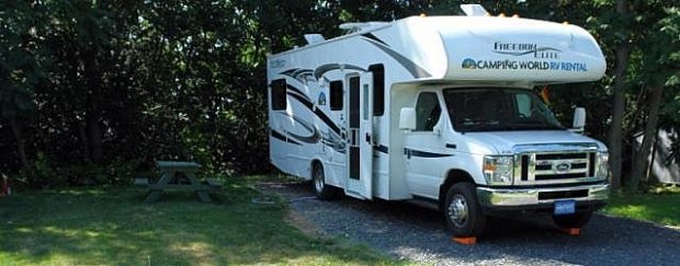
Der Mountain Shadows RV Park ist ein privater Campground in Draper in der Salt Lake City Region. Etwas weiter entfernt von Salt Lake City Downtown (ca. 15 mls), dafür liegt er direkt (max. 200m) neben der Moturis/Camping World Station Salt Lake City.

Am Nordrand von Baker City neben Hwy-30. Die Gebäude (Rezeption mit Store, Waschhaus etc.) verbreiten "Oregon-Trail-Romantik".

Die Multnomah Falls sind ein großer zweistufiger Wasserfall, der sich sehr einfach entdecken lässt.
Über den Wasserfall erstreckt sich eine Brücke, von der man einen schönen Ausblick auf den Columbia River Gorge als auch den Wasserfall hat.

Hat das Flair eines Parkplatzes, aber in 500m einen wunderschönen Strand.

Sehr schöner, am Strand gelegener Campground, der zum Verweilen und zum Baden einlädt. electric+water.

Dieser CG liegt direkt an den Hot Springs bei den Arrow Lake, der CG liegt weit außerhalb der Stadt, ein Besuch des Bades ist empfehlenswert. Es gibt in der Nähe auch schöne Spazierwege zu Wasserfällen.

Sehr schöner großügig angelegter Campground -- direkt an der Küste

Im Wald gelegener Campground des North Cascades National Park. Dumpstation vorhanden. Blick vom Newhalem Visitor Centre.

Die Sites (alle No-Hookup) liegen meist im Wald, haben eine Bank-Tisch-Kombination und einen Feuerring.

Staatlicher Campground mit (no hook up) Sites in einem Wald. --- Tisch-Bank-Kombi, Feuerstelle, gut zu leveln, viel privacy, Lake mit Strand und Badegelegenheit, Spielplatz, Dumpstation, Sanitäranlagen (Dusche/WC)

Idealer und schön gelegener Campground für Rückgabe des Wohnmobils bei Fraserway Cookstown. Der Campground hält auch immer einige Plätze für Fraserway Kunden frei.

Schöne Lage an einem See-

Schöner Campingplatz direkt am See mit Sandstrand. Man kann zu Fuß in die Stadt laufen.

Sauber angelegter CG.

Schön angelegter privater Campground für den Besuch von St. Augustine. Gute Alternative, wenn der Anastasio SP voll ist.
Einer von vielen, schön am aufgestauten Snake River gelegenen Campgrounds. Ein Paradies für Wassersportler. Eine Dumpstation ist vorhanden und alles ist frei.

Der Hwy-12 in Idaho führt von Lewiston bis Missoula am Clearwater River und Lochsa River vorbei, später über den Lolo Pass. Einsame Wälder, schöne Badestellen, Rafting (im Frühjahr), Wandern, Hot Springs.

Großzügig angelegter Campground am Santa Fe River. Wanderungen zu den "Sinkholes" Der Fluß verschwindet im Boden und fließt unterirdisch weiter.
-- noch kein Bild vorhanden --
Alle 67 Sites (Water only and W/E) sind fcfs.

Schön gelegener Campground in der Mitte der Outer Banks. Direkter Zugang zum Meer mit kleinem Pool. Sehr gutes Preis-Leistungs Verhältnis mit Full Hook Up.

Wir waren nach dem sehr schönen Sunset Beach CG vom Oceano etwas enttäuscht. Die Oceanside Stellplätze haben fast ein wenig Stadt-CG-Charakter. Sie sind eng beieinander.
-- noch kein Bild --
Oceano Campground has 24 campsites and each site will accommodate up to 8 people with either one RV or a couple of tents. Each campsite is equipped with full hook-ups (electricity, sewer, and water). Coin-operated showers are available.
Der RV Park liegt nur ca. 10 min. vom Strand empfernt, ist sehr sauber und gepflegt. Die Sites sind recht eng, wie an den Küsten-Plätzen oft üblich. Direkt hinter dem Park geht eine Bahnlinie vorbei.

Einziger, unter Obhut des National Park Service stehender Campground auf den Outer Banks, welcher reservierbar wäre. Ca. 4 Meilen außerhalb Ocracoke direkt an der NC-12. edit by Matze 4-23: auch die anderen 3 NP CGs sind mittlerweile reservierbar

Idyllischer, ruhiger Campground ideal zum besuchen von Mono-Lake sowie Bodie.

Im Mount Rainier National Park gelegener großer Campground mit 194 Sites. Im Wald. Sanitärhäuschen mit WC und Waschbecken. Dumpstation.
-- noch kein Bild vorhanden --
Insgesamt 60 Stellplätze, alle full hook-up, Kabel-TV und WiFi. Es gibt eine große Lobby mit Bibliothek, Küchenzeile und dazu Münzwaschautomaten und -trockner.

Kleiner hoch oben über dem Lake Michigan gelegener Campground ganz in der Naehe von Manistee. Man kann über eine Treppe direkt zum Strand kommen. Die Standplätze sind weit genug voneinander.

Die Sites des CG sind meist recht gross und schattig gelegen. Dort steht man mit dem Womo unter Bäumen, die mit Moos behangen sind. Die Zufahrt des CG führt über eine Holzbrücke, die schon recht eng ist. Dort empfiehlt es sich, langsam und vorsichtig zu fahren!

Die Outer Banks sind eine 280 Kilometer lange, zusammenhängende Inselkette vor der Küste North Carolinas. Hier erwartet den Besucher ein traumhaftes wildes und warmes Meer, viel Platz und Abgeschiedenheit.

Schöner Campground und Provincial Park mit vielen flachen Sandstränden.

Sites sind recht eng, Tisch, Bank und Full Hookup pro Site für 50 $.
Pull-Through sind grösser aber auch teurer (ab 56$).
Wunderschön ruhig und direkt an den Dünen gelegen.

Resortartig angelegter CG mit eher engen, geteerten Sites. Tolle Lage direkt an der Küste . 1A sanitäre Anlagen und Laundry. In- und Outdoor Pool.
-kein Bild vorhanden-
Schön direkt am Baker Lake. Wegen dem Zugang zum See ist der CG sehr beliebt, (Einheimische mit Booten), Vorbuchung wäre hier angebracht. Wir haben für 1 Nacht eine Site bekommen, für 2 Nächte wäre es aber nicht möglich gewesen. Die Sites waren etwas kleiner als man sie in den SPs sonst hat.

Ideale Lage zum Strand und zentral gelegen.

Von der I95 Exit 31B von Süden oder Exit 31 von Norden kommend ca. einen Kilometer auf dem W Oakland Blvd. dann an der Ampelanlage links und nach ca. 150 m ist das Ziel ereicht.

Der State Park verfügt über 45 Stellplätze mit Wasser und Stromanschluss. Der Platz ist großzügig angelegt, die Plätze befinden sich z. T. im Wald.


RV-Resort an der Ostseite von Vancouver Island. Direkt neben dem Campground ist der Parksville Community Park mi Kinderspielplatz und dem alljährlich im Sommer stattfindenden Sandskulpturen-Wettbewerb

Schöner Campground, mit Bademöglichkeit und Feuerringen.

Dies ist nicht wirklich ein Highlight, aber eine schöne Stelle am Colorado, wo man mit Womo (gratis) parken und es sich am Wasser gemütlich machen kann.

Sehr schöner Campground in lichtem Wald, liegt an einem Badesee, welcher in ca. 10-15 Fussminuten den Hang hinunter erreicht werden kann. 90 grosszügige Sites, davon 47 reservierbar.

Im Verlauf des Nebo Loop Scenic Byway gelegener ruhiger CG an einem See.

Der sonnige mit viel Rasen bedeckte Campground bietet Plätze unter schattigen Bäumen direkt am Sandstrand des Sees. Der Park liegt am malerischen Pearrygin Lake ca. 10 Minuten Fahrzeit nördlich vom Westernstädtchen Winthrop.

Ein sehr schön gelegener State Park, gepflegt und sauber. Gute Bademöglichkeit. Sehr geeignet für Besuche der Lyndon B Johnson Ranch oder Luckenbach, Fredricksburg, auch Austin ist erreichbar.

Platz mit Full Hockup, sauberen, großzügigen Duschen und WC, gepflegt, im Bereich der Half Moon Bay. Sehr netter Besitzer.
Schöner Sandstrand 5 Minuten zu Fuß. Vom Platz sieht und hört man das Meer. Gleich daneben befindet sich ein Golfplatz.

Schön gelegener, aber was die Ausstattung betrifft, einfacher Campground im Peninsula State Park.

Campground in einem County Park an einem Inlandsee in der Nähe der Big Bay des Lake Superior. Sites von rustikal bis FHU. Gechillter Platz am Rande einer Mini-Siedlung am Lake Independence mit großen Parkbäumen. Manche Sites etwas uneben mit Mud/Gravel Untergrund.

Es ist der erste State Park in Arkansas mit vielen Hikingtrails, außerdem kann man sehr gut angeln und im Sommer schwimmen (Pools). Strom und Wasser vorhanden, Dumpstationn
Liegt in einem Vorort von Philadelphia und daher eine gute Position für einen Stadtbesuch dort. Pool, WiFi, Full-hook-ups, Laundry.

Kleiner privater Campground direkt am Strand der Holly Beach

Wunderschöner Platz direkt am Pinoak Lake. Full Hook-up, große Stellplätze, großer Abstand, ausgesprochen gepflegt.
Der Campground ist Teil des Pinantan Resorts und direkt am See gelegen. Die Stellplätze mit full-hookup sind klein und liegen direkt nebeneinander. Sitzgruppe ist vorhanden. Man kann die Feuerstelle am Ufer nutzen.

Die Anlage ist recht weitläufig, die Sites für einen privaten CG recht groß und auch durch Bewuchs so voneinander separiert das man seine Privatsphäre hat. uper Standort, um gleich morgens Plymouth Pantation und Plymouth zu besuchen.

Self-Check-In. Alle Stellplätze sind im Wald. Es gibt großzügige saubere Vault-Toilets, ca. eine für 3-4 Sites. Die Sites sind recht groß und weit auseinander.

Dieser Campground macht von seiner Homepage her einiges her, aber direkt vor Ort (im Juni 2013) hatten wir das Gefühl, dass dort noch reichlich gebaut wird.

Recht enger, privater Campground. Es gibt die üblichen Annehmlichkeiten eines privaten Platzes.
Der Pool ist sehr schön und es gibt einen netten Spielplatz für Kinder. Alles sehr sauber.
In der Nähe verlaufen Bahnschienen. Störende Züge sind uns nicht aufgefallen. Der Strand ist nicht fussläufig erreichbar.
Der KOA liegt in unmittelbarer Nähe des I-95 in einem Wald, in etwa auf halber Strecke zwischen Savannah und Charleston, allerdings auch mit den damit verbundenen Nachteilen.

In dem Gebiet gibt es sechs natürliche Seen und weitere 15 tiefe Seen, die ehemalige Bergwerksgruben waren. Heute ist die Gegend ein Paradies für Mountainbiker und ein netter Platz, um im Sommer in die eiskalten Seen zu springen. Das Wasser ist dabei herrlich klar. Der Portsmouth Campground liegt inmitten dieser Seenlandschaft und hat 29 sites, 18 davon mit Strom.

Ein preiswerter Campground mit Pool und Laundry.

Auf dem Weg von Cleveland zu den Niagara Fällen liegt diese herrliche Halbinsel. Überall sind Möglichkeiten zum Baden, Boot fahren, Segway, Radfahren oder einfach nur zum Spazieren gehen. Ein kleines Paradies ...

Strom, Wasser, Duschen, Brennholz, Sani Station. Ein schöner Campground am Similkameen River

Gepflegter Campground im Prineville State Park, 16 Meilen von Prineville. Ganz ebene Stellplätze. Wenn man keinen Strom braucht, kann man mit dem Womo auch auf die Tent Sites gehen, die liegen direkt am Wasser-
- kein Bild vorhanden -
Privater CG direkt gegenüber vom Royal View CG, 33 $ / Full Hookup.
Spielplatz, Pool, Hot-Tub, Hüpfkissen, Wasserspritz-Feld (Splash-Pad), Game-Room, WiFi...

Es gibt nur wenige, kostenlose Badestellen wie im Paradies! Dieses ist eine von ihnen.

Guter Zwischenstopp auf dem Weg vom/zum Zion Nationalpark. Wirklich schöner Campground direkt am See. Sehr gute Bademöglichkeit. Die Sites sind leicht am Hang über dem See und bieten schöne Ausblicke.

Kleiner Campground mit lediglich 12 Sites etwa in der Mitte des Ostufers am Bear Lake. Für jeweils 2 Sites gibt es ein Klohäuschen. Alle Sites ohne Anschlüsse aber mit Firering. Keine Dumpstation, kein Frischwasser.

Dieser Campground hat eine ideale Bademöglichkeit und eignet sich hervorragend als letzte Station vor der Abgabe bei Campingworld in Denton, wenn der Rückflug von Fort Worth geht. Die Fahrzeit Isle Du Bois - Campingworld beträgt 30 Minuten/17Meilen.

Gut geeignet für eine Übernachtung, sauber, Pool, Waschmaschine.

Der Park wird 2023 nach dem Sturmschaden verkauft (siehe Post #5)-- Wiedereröffnung noch nicht gesichert ---- Der Campground hat eine gute Lage, da er direkt am Strand liegt und sich in der Nähe einige Restaurants und Geschäfte befinden, die zu Fuß leicht zu erreichen sind. Gegenüber vom Strand gibt es weitere Stellplätze, die etwas billiger sind, als die Sites am Meer.

CG in einem ruhigen State Park 10 Meilen nördlich von Vernal, Utah. In der Nähe Flaming Gorge National Recreation Area und Dinosaur National Monument. Trail zu 200 Millionen Jahren alten Dinosaurier Spuren.
-zur Zeit noch kein Foto verfügbar-
Der Campground liegt direkt am Hwy-212, 10 Meilen nördlich vor dem kleinen Ort Red Lodge, nordöstlich des Ostzufahrt des Yellowstone NP über den Beartooth Highway. Es sind cabins (Huetten) vorhanden, sowie Full Hookup Stellplaetze.

Sehr großer CG. Plätze zwischen schönen Redwoodbäumen. In einem Hang gelegen.

Weitläufiger, sehr schön gelegener Platz im State Park oberhalb des Ridgway Reservoirs auf ca.7000 ft Höhe. Großzügige Stellplätze mit Strom. Mehrere Plätze teilen sich einen Frischwasseranschluss. Zentrale Dump Station. 2130 m NN.

Wunderschöner Campground und idealer Zwischenstopp zwischen Denver und Moab mit Abendspaziergang zu den Wasserfällen. 13 RV/Tent-Campsites.

Es gibt fünf Campgrounds, alle an der Nordseite des Sees und mehr oder weniger in Sichtweite zueinander. Insgesamt stehen 89 Stellplätze zur Verfügung, teilweise mit HookUp aber auch ohne. Die Sites sind online reservierbar.

Ein Campground entlang der Küste -- aber ganz nah an der CA-SR-1

Der River Island State Park liegt ca. 1 Meile nördlich des Buckskin Mountain State Parks. Hat E- und W-Hook-ups, was im Sommer von Vorteil ist. Z. T. nahe an der Strasse, aber empfehlenswert.

Der Platz ist übersichtlich und hat einen schönen Zugang zum Fluss, welcher zum Baden einlud. Kanus konnte man sich auch ausleihen. Ein Stromanschluss war vorhanden, je nach Platz 30A oder 50A. Die sites sind relativ eng beieinander.
Sehr großer Campground mit allen Annehmlichkeiten eines privaten Platzes. Lage zwar in der Nähe der Interstate 8, aber als Zwischenstopp zwischen Joshua Tree / Organ Pipe empfehlenswert.

Der Campground des Riverside State Park befindet sich in der "Bowl & Pitcher Area". Er liegt in Spokane / Washington, direkt am Spokane River.
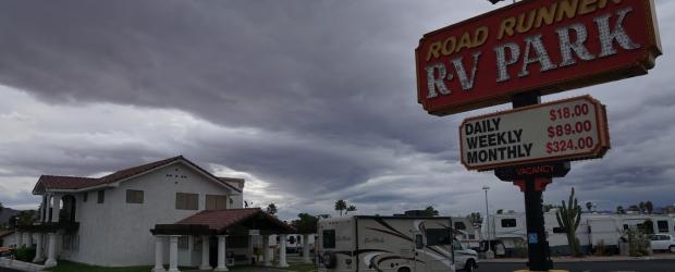
Road Runner RV Park ist eine ausgezeichnete Alternative für die Abgabe des WoMo in Las Vegas bei Road Bear. Der CG liegt direkt gegenüber der Road Bear Station. Bushaltestelle ca. 1 Block entfernt.

Sehr schöner CG unter Bäumen, manche direkt am See, Strand, Strom, Duschen und Toiletten. Rock Lake Campground is located 8 km south of km 40.3 of Highway 60 on the Rock Lake Road (gravel 8km)

Die Sites (alle No-Hookup) liegen meist im Wald, haben eine Bank-Tisch-Kombination und einen Feuerring.

Am Rogue River gelegener privater Campground mit Full Hookup und Laundry. Sehr kleine Sites, aber schöne Sitzgruppen direkt am Fluss. Man kann den Pool und die Hot Tub des auf der anderen Straßenseite gelegenen Hotels Edgewater Inn mitbenutzen.
Schöner Campground unter dichten Bäumen direkt am Rolley Lake und nur ca. 1 Stunde von Vancouver entfernt.

Staatlicher Campingplatz im Rondeau Provincial Park. Zugang zum Strand am Lake Erie. Sites teilweise mit Stromanschluss.

Ein kleiner Park mit Fuss-und Radwegen, bekannt für Vogelbeobachtungen, einer der ältesten PP in Kanada

Recht einfacher privater CG, mit nur-Strom- bis Full-Hookup-Sites. Kein W-Lan aber mit Pool und Laundry.

Er liegt weit genug abseits von der Hauptstraße, sodaß keinerlei Lärmbelästigung vorhanden ist. Die Stellplätze sind ausreichend groß aber relativ dicht nebeneinander. Schatten gibt es nur sehr wenig.
Es ist ein schöner Platz mit Pool und Spielplatz. Wenn man nicht mit dem Womo in San Diego herumfahren will, wäre ein Mietwagen angebracht. Mit diesem sind alle Sehenswürdigkeiten schnell erreichbar.

Ein Strand-Campground an einem langen Sandstrand (zusammen mit Cardiff State Beach) zwischen Los Angeles und San Diego. Der CG liegt zwar an einem sehr schönen Strand, ist aber grundsätzlich sehr einfach gehalten. Straße und Bahnlinie sind zu hören.
Sehr gepflegtes Camping Resort. Schöner Pool. Kurze Wege ins Napa Valley und Outlet Mall direkt im Ort.

Wenn man San Francisco mit dem Wohnmobil besucht, ist dies ein schöner Platz am Pazifik. Nach Downtown mit Mietwagen oder Bus.

San Mateo Campground, ein kurzes Stück im Inland gelegen, ist Teil der San Onofre State Beach, der andere, 3,5 Meilen lange Campground direkt am Pacific trägt den Namen San Onofre Bluffs

Der Campground mit 27 Sites ist wunderschön direkt am San Juan River gelegen. Unterhalb des CG fließt der River mit schönen Kiesbänken - ideal um mit Kindern schöne Steine zu sammeln.

Sanibel Island liegt an der Golfküste Floridas und ist über ein gebührenpflichtige Straße/ Brücke zu erreichen. Die Insel ist bekannt für sein großes Muschelvorkommen und seine tollen Strände. Hier ist vor allem der Bowman's Beach zu nennen.

Ein nördlich des Colorado und der I-8 gelegener privater Campground, der vorwiegend von Dauercampern belegt ist.

Ein wunderschön angelegter Park, weitläufig, gepflegt und weitgehend naturbelassen, mit einen wunderschönen Blick auf den künstlich angelegten Stausee, der zur Wasserversorgung von Santa Rosa dient.

Zufahrt über eine 12km lange Gravelroad die bei unseren bislang zwei besuchen in gutem Zustand waren. Aber das kann sich ja erfahrungsgemäß sehr schnell ändern.
--noch kein Bild --
Privater Campground entlang des HWY-6 mit Blick auf die Northumberland Strait

Ein idyllisch an einem See gelegener Campground -- im Herbst herrlich anzusehende Laubverfärbung. Die Stellplätze liegen teilweise sehr eng beieinander, so dass es in der Hauptsaison insgesamt eher unruhig auf dem CG wird.

Super Lage, freundlicher Host, nahe am Strand (Equipment Surf Boards,.. vorhanden)


Sehr schön gelegener Campground am Big Bear Lake.
--noch kein Bild vorhanden --
Ein US-Army Corps of Engineers - Campground an einem See ( Percy Priest Lake ) in der Nähe von Nashvills. 58 sites mit water+electric.

Der ansprechende CG besteht aus vier kleinen Loops mit gesamt 50 großzügigen und mehrheitlich schattigen Sites unter Bäumen.
-- noch kein Bild vorliegend --
Aus Mare TV ... ein genial gelegener Campground mit Sites auf dem Strand. Ideal für ein paar Tage Standurlaub.
Achtung, in der Saison (1.4.-11.11.) gibt es zwei Restriktionen: 3 days minimum stay, No checkin Saturday or Sunday.
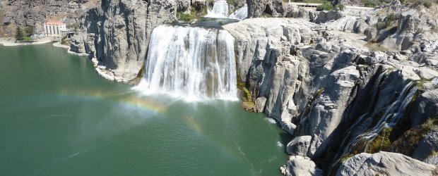
Die Shoshone Falls in der Nähe von Twin Falls ID sind wirklich sehr schön anzuschauen und werden als "The Niagara of the West" bezeichnet.

Schöner Campground under permit USDA Forest Service. Liegt an der Nordseite des Rimrock Lake und es gibt rd. 15 sites direkt am See.

In unmittelbarer Stadtnähe gelegener CG. Man steht zwar dicht an dicht, aber direkt am Meer und man kann sogar baden, weil der Pazifik im Süden annehmbar warm ist. Reservierung über reserve california ist zu empfehlen.

Der Platz liegt direkt am Christina Lake, hat Strom und Wasserversorgung. Die Stellplätze sind schön schattig.

Eine klasse Badestelle, gerade für Kinder, befindet sich direkt an der Anfahrt auf der Hwy-198 von Visalia zum Sequoia NP ca. 1 Meile westlich vom Ortsschild Three Rivers.

Natürliche Wasserrutschen im Oak Creek. Achtung: Das Wasser ist auch im Sommer ziemlich frisch.

Schöne Wiesen-Sites welche nur durch ein kleines Wäldchen und einer Böschung getrennt direkt am See gelegen sind. Saubere Sanitäranlagen und eine kleine Poolanlage welche aber zu unserer Reisezeit nicht mehr im Betrieb war.
-- noch kein Bild vorhanden --
Sehr großer privater Campground mit 854 Sites. Es handelt sich um einen "Club RV Park - Members only". Aber wie man sieht, es geht auch ohne Clubmitgliedschaft. Die Stellplätze sind von sehr schattigen Bäumen umgeben.

Water & Electricity, kostenlose Dusche, Tisch/Bank, Feuerstelle, Feuerholz

Eine gute, weil noch urtümliche Alternative direkt hinter dem Watchman CG.

Zwischen Los Angeles und San Diego gelegener Beach- Campground

Ein Campgound im Bereich des Hwy-49 im Gebiet des kalifornischen Goldrushs
Hook-up Plätze, Dump Station, WC, Dusche, Laundry, Kiosk bzw. kleiner Laden mit Imbiss, Feuerring, Tisch-Bank Kombination auf den Sites vorhanden.

Sehr gepflegter Park. Bademöglichkeit, Wandern

Der State Park liegt auf der Strecke nach Denver und eignet sich sehr gut für eine Zwischenübernachtung. Er ist sehr schön gelegen und bietet vom einfachen Stellplatz bis zum Full Hook Up alle Möglichkeiten.
-noch kein Bild verfügbar-
Dieser ehem. KOA Campground liegt in der Nähe der Luray Caverns im Shenandoah Valley mit Blick auf die Blue Ridge Mountains.

Ein guter Bade-Stopp am Lake Roosevelt. Ranger-Programm für Kids und Erwachsene, Kanu-Touren.

National Forest Service Camground am Bass Lake (gut 50 Meilen bis ins Yosemite Valley). Eignet sich gut als Ausweichplatz zum Besuch des Yosemite National Park (gut 50 Meilen bis ins Yosemite Valley). Elevation 3400 feet.
-- noch kein Bild vorliegend --
Ein KOA in der Nähe der Kreuzung der I-55 und I-72 auf dem Weg von / nach St. louis
Privater Campground direkt am Flathead River. Guter Ausgangspunkt für Glacier National Park. Gärtnerisch gesataltetes offenes Gelände mit Wiese und einigen Bäumen. Die Plätze direkt am Flathead River haben nur Water+Electric, sonst full-Hook-Ups. Die Plätze am Fluß haben eine überwältigende Aussicht auf River und Berge.

Der Spur 406 Campground ist absulut einsam und ohne Facilities. ganzjährig geöffnet, fcfs.

Guter Platz mit Strom & Wasser, allerdings recht enge Stellplätze. Ideal zum baden, super weißer Sandstrand. Zum Strand muss allerdings mit dem Womo gefahren werden, da ca. 2km entfernt.

Aktuell 2022: szeht nicht mehr für Camping zur Verfügung -- siehe Post #9 ----- Keine Schönheit, aber idealer Stadt-Campground. Downtown und Gateway Arch gut zu Fuss erreichbar. Bus-Station gegenüber.
KOA an der Historic Route 66, 30 Meilen von St. Louis entfernt. Zugverkehr insbesondere nachts störend.

In 2.400 m gelegener State Park am Steamboat Lake, ca. 30 mls nördlich von Steamboat Springs am #129. (Kalter) See, Wandern, Kayakverleih.

Der CG liegt auf einer Halbinsel im Banks Lake und besteht aus drei Loops. Die sites liegen auf auf baumbestandenen Wiesen und haben überwiegend full Hook-up.

Ein wunderschön direkt am Wasser des südlichen Muncho Lake gelegener Campground mit 15 Sites. Tisch/Bank - Kombi, Feuerringe, Pit Toilets vorhanden.

Wasser + Elektrik oder Full-Hookup, Shop, Restaurant, Bar, Horseshoe, Spielplatz, Volley Ball, Billiard, Fahrradverleih .....Laundromat, freie Duschen

Schöne Lage auf über 2000m, direkt am See. Stellplätze zum Teil eng.

Ein schöner SP mit Wandermöglichkeiten und Wildbeobachtung und ein See, der Wasser hat!

Private Alternative, wenn kein Platz mehr auf den umliegenden Campgrounds am Tim Fords Lake zu bekommen ist. Keine Sitzgelegenheit, kein Sichtschutz, keine Feuerringe. An der Zufahrt zum Tims Ford Lake.
- keine Fotos -
Privater Campground am Cultus Lake, in der Nähe von Chilliwack südöstlich von Vancouver. Über 350 Sites, davon 104 FullHookUp, geöffnet von Mitte April bis September. Waschmaschine vorhanden, kostenlose Duschen.

Großer Campingplatz mit mehreren Loops am Südufer des El Dorado Lakes. Kein Strom, Wasser zentral, Dump Station. Große Stellplätze meist direkt am Ufer, große Abstände, wenig Schatten.

Schöne Lage. Von den Sites A-Z hat man eine wunderbare Aussicht über die Küste. Weit genug von der Straße, um den Lärm nicht zu hören. Gut geeignet für den ersten oder letzten Tag. Preis sehr hoch, Sites sehr eng, kein Lagerfeuer.

Ein schöner Campground mitten auf einer Insel im See gelegen. Die Sites sind nicht groß, doch viele haben einen Seezugang.

Der CG verfügt über 119 Stellplätze, die mit Wasser und Strom ausgestattet sind. Die Stellplätze befinden sich auf der Golfseite und sind nur durch die Dünen vom Strand getrennt.

Ideal für den Branson-Besuch mit Lagerfeuer-Romantik. Zu den Shows fährt man 5-10 Minuten. Die Non Hook-up-Sites sind wie meist viel schöner.

Toller Boondockig Platz, ich würde ihn aber in Ferienzeiten und Wochenenden meiden. Die Übernachtung ist kostenlos, aber der Zugang erfordert eine "Fee".

Am Grassy Point gibt es zwei Campgrounds: den Bayside CG mit 12 Sites und den Bayou CG mit 4 Campsites. Hier trifft und lernt man Leute kennen.
-noch kein Bild verfügbar-

CG am Mineral Lake gelegen, sites auf der Wiese, viel Platz, 15$ pro Nacht.
-- noch kein Bild --
Geräumiger privater Campground an einem See im Norden der Metropolregion Dallas / Fort Worth

Ein sehr grüner und schattiger CG in einem am Snake River gelegenen State Park.

Ein vom US Army Corps of Engineers betriebener Campground.
Günstiger (im Vergleich zu Orlando) und sehr gepflegter KOA-Campground. Gut gelegen für die Besichtigung des Kennedy Space Centers.

Sehr schöner CG in Tobermory im Bruce Peninsula NP. Teuer aber gut mit Full Hookup.

Hier kommt man auf einem Wohlfühlcampground an. Der ganze Platz ist von aussergewöhnlicher Sauberkeit und Aufgeräumtheit, die Sites sind absolut gelevelt und die Facilities von hoher Qualität.

Einer von insgesamt 11 Campgrounds im Boyson State Park.
Auf einer Halbinsel gelegen mit teilweise sehr großzügigen Sites. Alle Sites mit Zugang zum See.

Schöner State Park 7 Meilen nordöstlich von Bend am Deschutes River gelegen. Sanitärgebäude sauber und große Einzelduschen vorhanden.

Als Zwischenstation von SF nach Womo Übernahme auf dem Weg zum Yosemite (bei einfahrt über Big Oak Flat, Hgw 120) recht praktisch gelegen.

Das Highlight des Campgrounds ist der direkte Zugang zum Turtle Beach. Einer der schönsten Strände in Florida, der einen tollen Sonnenuntergang bietet. Näher zum Wasser geht kaum noch, alles sauber und gepflegt.

Gute Alternative, wenn Indian Cove Campground u.a.innerhalb des Joshua Tree NP belegt sind. An der SR 62 und Amboy Road gelegen.

Großzügiger CG im Norden der Stadt.

Privater CG mit Full-Hookup-Möglichkeit, Sites oft auf Rasen, schöner Pool, großer Spielplatz, Laundry usw.

Der Campingplatz liegt wirklich sehr ruhig - ca. 12 Minuten von der I-5 entfernt - tolle Natur in der Umgebung.
In der Gegend gibt es einige Wineries, in denen man gut essen und Wein trinken, sowie kaufen kann.
Eine gepflegte Recreation Area, an 5 kleinen Seen gelegen. Sehr großzügige Sites mit Baumbestand, teilweise mit Stromanschlüssen. Grillplatz und Tisch-/Bank Kombination, Duschen und Toiletten sind vorhanden

Kleiner, sehr aufgeräumter Campground im südlichen Bereich der Oregon Dunes, hohe Bäume. Kleiner Badesee (Lake Marie) an den Campground grenzend.

Kleiner Campground, 16 Sites auf einer Wiese direkt am Umpqua River. Alles Full-Hook-Up.

Privater CG in Durango zwischen Mesa Verde NP und dem Million Dollar Highway mit den dort üblichen Annehmlichkeiten, z.B. Pool, Laundry, FullHookUp.
Campground südlich von Salt Lake City am Utah Lake gelegen (Bademöglichkeit). Campground ist nur 30 min. von der City entfernt. Ruhige Lage am See, Duschen und Full-hook-up.h

Der Venetian Pool befindet sich im Stadtteil Coral Gables in Miami. Er wurde aus einer Korallen-Steingrube erschaffen und daraus ist nun einer der schönsten Pools in den USA geworden.

Ein liebenswerter Platz, als Zwischenübernachtung für Route-66-Fahrer oder im Transit von Süd nach Nord.

Schöner, großzügiger Campground direkt am Lake Erie.

Der Campground liegt in idealer Lage direkt am Lake Powell bei der Wahweap-Marina. Der Preis für Hook-up (welcher manchmal nötig ist wegen der Hitze) ist aber hoch.
--noch kein Bild vorhanden -
Einer von drei Campgrounds im La Mauricie National Park mit 150 Seen und ausgedehnten Wäldern nordwestlich von Québec
- keine Fotos -
Guter KOA-Campground in der Nähe der I-70 / 79 südlich von Pittsburgh

Ein Top-Platz, wunderbar zwischen Bäumen am Virgin River gelegen. Mit Stromanschluss und absoluter Nähe zum Visitor Center, wo die Shuttlebusse abfahren. Frühzeitige Reservierung dringend empfohlen.
-- noch kein Bild --
"Where the Road meets the Bay -- kleiner (nur 10 Sites) privater Campground nahe bei der Magnolia Beach in der Lavaca Beach
KOA mit SPA-Bereich (Sauna, Schwimmbad und Fitnessraum).
Ruhiger und verkehrsgünstig gelegener State Park Campground hinter der Uferböschung des Flathead Lakes am Ostufer des Sees. Ein Teil der Stellplätze liegt schattig unter Bäumen.

Wunderschöner und riesiger staatlicher CG direkt in den Thousand Islands mit Strand und Bademöglichkeit, Spielplatz und Hafen, von dem direkt Bootstouren in die Thousand Islands möglich sind.

Wer Ranch Urlaub sucht ist hier richtig . Die Ranch besteht aus Haupthaus, Blockhaus mit großer Terasse und Blick zum See hier gibt es auch Frühstück ( buchbar) Es gibt verschiedene Zimmer zum Übernachten. Für Camper stehen WOMO Stellplätze zur Verfügung. Die Ranch befindet sich direkt am Henley Lake. (kurze Gravelroad vom HW) .Man kann wunderbar baden und es gibt Kayak´s. Es ist ein kleines Paradies.

Ein kleines Paradies mit Fluss innerhalb einer Canyonlandschaft mit sehenswerten Wasserfällen, mehreren tollen Badestellen, in einer im Sommer von der Sonne verbranden Landschaft. Leider nur day use only.

Auf dem wunderschönen Scenic Byway 12 gibt es in der Nähe von Escalante eine schöne Möglichkeit einer Abkühlung: Badestopp am Wide Hollow Reservoir, unweit des Escalante Petrified Forest State Park
-- noch kein Bild vorhanden --
Ein ruhiger State Park Campground an der Nordküste von Long Island östlich von New York City. Sehr schöne, recht große und schattige Sites, mit Kies, deshalb teilweise etwas uneben, dafür aber mitten im lichten Wald. Full Hookup, pull thru, nur 10 Minuten zu Fuß bis zum bewachten Sandstrand.
noch kein Bild vorhanden -
Kleiner, einfacher NF-Campground in Regenwald (21 Sites, max 22 feet) am Südufer des Lake Quinault, in der Nähe der Lodge

Wenn man nach Durchquerung des North Cascades NP keine Lust mehr auf langes Fahren hat. Guter KOA Standard, großzügige Sites.

Privater Campground in South Fort Lauderdale am Kanalsystem. Wie bei stadtnahen CG´s sind die Sites recht eng und haben keine Tisch-Bank-Kombination. Schöner Pool.

Neben dem Grand Canyon das Highlight im Südwesten. Sehr viele schöne Wanderungen. Tunneldurchfahrt für WoMo´s kostenpflichtig (Achtung: Änderung ab Mitte 2026 - siehe unten) !. Reservierung für Campgrounds empfehlenswert.